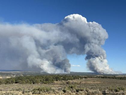
Colorado wildfires: More than 8,000 acres scorched by fires on Western Slope
Published in News & Features
DENVER — Three wildfires that started over the weekend on Colorado’s Western Slope have consumed more than 8,000 acres and destroyed at least three buildings, according to fire officials.
All three lightning-sparked fires are burning near Meeker, a town in Rio Blanco County that sits about 70 miles northwest of Glenwood Springs and 40 miles north of Interstate 70.
The Grease and Lee fires southwest of Meeker
Two wildfires burning 18 miles southwest of Meeker have together scorched roughly 5,000 acres with no containment, fire officials said Monday.
Officials said the Grease and Lee fires grew rapidly Monday amid high heat, low humidity and gusty winds. Those conditions are forecast through Thursday, with multiple red flag warnings and fire weather watches active for the Western Slope.
The Wyoming Type 3 Incident Management Team 4 took command of both fires at noon Monday.
The Lee fire started at about 11 p.m. Saturday, and the Grease fire ignited at 1 p.m. Sunday, fire officials said.
About 60 firefighters and two helicopters are battling the blazes, fire officials said.
“We understand there are growing concerns about fire activity in the area,” sheriff’s officials said Monday. “At this time, the Town of Meeker is NOT under any pre-evacuation or evacuation orders. … However, with active wildfires in the region and ongoing dry conditions, it’s always a good idea to be prepared.”
As of Monday evening, evacuation orders for the Lee and Grease fires included:
•County Road 22 off of County Road 5, including Little Hills;
•County Road 76 from County Road 3 to County Road 5;
•Colorado 64 from mile marker 58 to mile marker 72;
•The area south of Colorado 64, including County Road 127, County Road 129, County Road 66 and Brightwater Lane;
•And County Road 33.
Road closures in the area include County Road 8 from mile marker 11 to mile marker 19, County Road 3, County Road 22, County Road 26 and the intersection of County Road 127 and County Road 129.
The Elk fire east of Meeker
Another large wildfire is burning on a combination of private, state and Bureau of Land Management land about 11 miles east of Meeker, fire officials said Monday.
The Elk fire was last mapped at 3,000 acres with no containment and, as of Monday, had destroyed two homes and an outbuilding, according to BLM Colorado.
It was first reported just after noon Saturday, sheriff’s officials said.
No update on the fire’s size, containment or destruction of buildings was available Tuesday.
As of Monday evening, evacuation orders remained in place for:
•County Road 8 from mile marker 11 to mile marker 16,
•A stretch of land north of County Road 8 from Sleepy Cat Ranch to Lake Avery,
•County Road 40,
•County Road 63,
•And County Road 49.
Pre-evacuation orders were issued for County Road 8 from mile marker 16 to mile marker 27, County Road 14 and County Road 57, sheriff’s officials said.
©2025 MediaNews Group, Inc. Visit at denverpost.com. Distributed by Tribune Content Agency, LLC.


Comments