Tropical Storm Erin surges through Atlantic with Caribbean islands now at risk, NHC says
Published in News & Features
Tropical Storm Erin on Tuesday continued to push west through the Atlantic as the National Hurricane Center forecasted it to become a major hurricane with Puerto Rico and other Caribbean islands in its potential path.
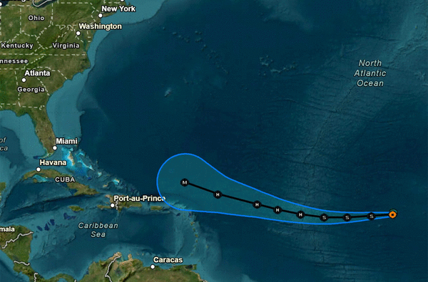
As of the NHC’s 5 p.m. Eastern time update, the center of Erin was located about 1,635 miles east of the northern Leeward Islands of the Caribbean moving west at 22 mph with maximum sustained winds of 45 mph. Tropical storm-force winds extend out 35 miles.
“A slightly slower westward motion is expected tonight through Thursday, with a west-northwestward motion beginning Thursday night and continuing into the weekend. said NHC Warning Coordination Meteorologist Robbie Berg. “Little change in strength is expected during the next day or so, but gradual strengthening is forecast to begin by late Wednesday. Erin will likely become a hurricane by late Thursday.”
While there are no watches or warnings in place, the NHC advised the northern Leeward Islands, Virgin Islands and Puerto Rico to monitor Erin’s progress.
“A quick south-of-due-west motion is expected to continue for the next 24 hours, with strong low- to mid-level ridging located to the north over the central and eastern Atlantic. Global models indicate that ridge is likely to weaken in a few days, which should cause Erin to begin moving west-northwestward in about 60 hours, with that motion continuing through day 5 (Sunday),” Berg said.
The forecast from the NHC has Erin intensifying into what would be the season’s first hurricane with 75 mph sustained winds within two days, making it a Category 1 hurricane.
The forecast predicts it will grow into a major Category 3 hurricane with 115 mph sustained winds and gusts of 140 mph by Sunday morning with the cone of uncertainty encompassing a wide swath in the Atlantic that includes the Leeward Islands, Virgin Islands and Puerto Rico. Winds could potentially be felt in the islands beginning Friday.
The National Weather Service in Melbourne said it was too early to determine if there would be any Florida impacts.
“We are entering peak hurricane season. Use this time to ensure you are prepared ahead of any threats,” forecasters said.
The NHC also is tracking one other Atlantic system and one in the Gulf.
As of the NHC’s 2 p.m. Tuesday tropical outlook, the Atlantic system had only a 10% chance of development and the Gulf system had 0% percent chance, but forecasters warned of tropical rainfall over the northern Gulf coast.
The surface trough that was near the coasts of Louisiana, Mississippi and Alabama had a broad area of disorganized showers and thunderstorms.
“While development of this system is not anticipated before it moves inland (Tuesday), locally heavy rainfall could produce flash flooding across portions of the northern Gulf coast over the next day or so,” forecasters said.
The remaining system was a nontropical area of low pressure a few hundred miles southeast of Nova Scotia, Canada, with disorganized shower and thunderstorm activity.
“Some limited tropical or subtropical development is possible through early Wednesday as the low meanders near the relatively warm waters of the Gulf Stream,” forecasters said. “The system is expected to move northward over cooler waters later on Wednesday, ending its chances for tropical development.”
After Erin, the next names on the 2025 Atlantic hurricane season would be Fernand and Gabrielle.
The National Oceanic and Atmospheric Administration last week updated its season forecast now calling for 13-18 named storms for the year, of which five to nine would grow into hurricanes. Two to five of those would develop into major hurricanes of Category 3 strength or higher.
The height of hurricane season runs from mid-August into October while the entire six-month season runs June 1 to Nov. 30.
_____
©2025 Orlando Sentinel. Visit at orlandosentinel.com. Distributed by Tribune Content Agency, LLC.


Comments