Hurricane Erin forecast to form today, threaten Caribbean, NHC says
Published in News & Features
ORLANDO, Fla. — Tropical Storm Erin is forecast to become the season’s first hurricane Friday and threaten the Caribbean before turning away from land where it will intensify further in the Atlantic, according to the National Hurricane Center.
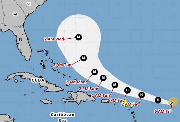
As of the NHC’s 8 a.m. advisory, the center of Erin was located about 520 miles east of the northern Leeward Islands moving west-northwest at 17 mph with maximum sustained winds of 70 mph, just shy of Category 1 hurricane strength. Its tropical-storm-force winds extend out 90 miles.
“This motion is expected to continue into the weekend. On the forecast track, the center of Erin is likely to move near or just north of the northern Leeward Islands over the weekend,” said NHC hurricane specialist Larry Kelly. “Steady strengthening is expected during the next few days and Erin is forecast to become a hurricane later today and could become a major hurricane by this weekend.”
A tropical storm watch is in place for Anguilla and Barbuda, St. Martin and St. Barthelemy, Saba and St. Eustatius, and Sint Maarten.
The system is expected to drop heavy rains late Friday and into the weekend with up to 6 inches in some parts across the northernmost Leeward Islands, the U.S. and British Virgin Islands as well as southern and eastern Puerto Rico. Flash flooding, landslides and mudslides are a threat.
The system passed by the Cape Verde Islands earlier in the week, causing flash floods that were blamed for at least nine deaths. It has been moving quickly across the Atlantic.
The swells from the storm with dangerous surf and rip currents will begin hitting the northwestern Caribbean islands today, and spread to the Bahamas, Florida and rest of the U.S. East Coast as the storm intensifies and moves up into the Atlantic.
“A subtropical ridge to the north will continue to steer the system west-northwestward into the weekend. A weakness in the ridgeis forecast to develop early next week, and this will result in the system gradually turning northwestward then northward by the end of the forecast period,” Kelly said. “There is still uncertainty about what impacts Erin may bring to portions of the Bahamas, the East Coast ofthe United States and Bermuda in the long range.”
The storm is moving into warmer Atlantic waters and wind shear is forecast to diminish.
“The storm is in a favorable environment for strengthening, and it will likely intensify once the inner core becomes more organized,” Kelly said. “Erin will be a large and powerful hurricane over the southwestern Atlantic Ocean this weekend.”
The forecast track has it growing to a Category 3 major hurricane with 115 mph winds by early Sunday. Its peak intensity is forecast to hit by early Monday with as much as 130 mph sustained winds and 160 mph gusts, making it a Category 4 hurricane.
In addition to Erin, the NHC continued to keep track of a disturbance in the western Gulf.
As of the NHC’s 8 a.m. tropical outlook, shower activity had persisted for the system located about 75 miles off the coast of northeasternMexico and southern Texas coastline.
“The system could become a short-lived tropical depression before it moves inland this afternoon or evening,” forecasters said. “Regardless of development, locally heavy rainfall is possible along portions of northeastern Mexico and southern Texas over the next couple of days, and interests there should monitor the progress of this system.”
Another Air Force Reserve Hurricane Hunter aircraft is scheduled to investigate the system later this morning.
The NHC gave the system a 50% chance of development in the next two days.
After Erin, the next name on the 2025 Atlantic hurricane season would be Fernand.
The National Oceanic and Atmospheric Administration last week updated its season forecast now calling for 13-18 named storms for the year, of which five to nine would grow into hurricanes. Two to five of those would develop into major hurricanes of Category 3 strength or higher.
The height of hurricane season runs from mid-August into October while the entire six-month season runs June 1 to Nov. 30.
------------
©2025 Orlando Sentinel. Visit at orlandosentinel.com. Distributed by Tribune Content Agency, LLC.


Comments