Hurricane Erin will bring dangerous conditions to US coast, despite offshore path
Published in News & Features

FORT LAUDERDALE, Fla. — Hurricane Erin will bring life-threatening surf and rip currents to parts of the U.S. East Coast this week as the storm tracks close enough to trigger tropical storm and storm surge watches.
And forecasters are concerned about two other systems that have a chance of forming in Erin’s wake, one currently traveling across the Atlantic off the coast of Africa.
Erin dropped to a Category 2 hurricane on Tuesday, with maximum sustained wind speeds of 105 mph, but it has grown quite large. Its wind field has increased substantially, said forecasters, with hurricane-force winds extending 80 miles from its center and tropical-storm-force winds extending out 230 miles. The storm’s significant width will push impacts toward the mid-Atlantic coast.
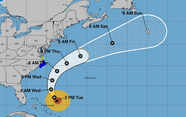
As of 2 p.m. Eastern time Tuesday, Hurricane Erin was about 655 miles south-southeast of Cape Hatteras, North Carolina. It was traveling north-northwest at 10 mph.
The storm is forecast to turn to the north Tuesday. Its track will take it about halfway between Bermuda and the U.S. coastline through this week.
The National Weather Service in Melbourne said the storm’s closest approach to Florida will be east of Cape Canaveral early Wednesday, so winds won’t be a factor. But high surf will be.
“Significant coastal and boating effects will be felt here. Building swells from Hurricane Erin will lead to an ongoing high risk of rip currents along with breaking waves of 5 to 8 feet producing rough pounding surf with minor beach and dune erosion, particularly during the high tide cycles,” the NWS stated.
“Swells generated by Erin will affect the Bahamas, Bermuda, the east coast of the United States, and Atlantic Canada during the next several days,” the hurricane center said. “These rough ocean conditions will likely cause life-threatening surf and rip currents.”
The NHC issued tropical storm and storm surge warnings for the North Carolina Outer Banks, and tropical storm watches from Duck, NC to Cape Charles Light, VA.
The Outer Banks should see tropical storm conditions beginning Wednesday night, along with the possibility of heavy rainfall Wednesday into Thursday, with the potential for 1 to 2 inches and a local maximum of 4 inches.
Storm surge, if it occurs at high tide, could be 2 to 4 feet above normal levels from Cape Lookout to Duck, North Carolina, said the NHC. “Storm surge will be accompanied by large waves,leading to significant beach erosion and overwash, making some roads impassible,” said the 2 p.m. outlook.
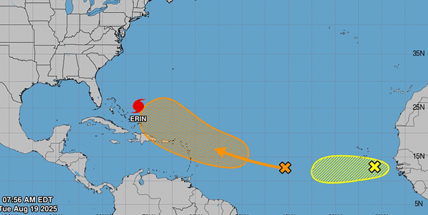
Bands of heavy rainfall should hit portions of the Turks and Caicos and the Bahamas eastward from San Salvador Island through Tuesday.
Several islands along the northeast border of the Caribbean Sea remained under tropical storm watches Tuesday.
The system over the central tropical Atlantic is currently a disorganized cluster of thunderstorms that could organize into a tropical depression or tropical storm by week’s end. It should reach the vicinity of the easternmost Caribbean Islands by Friday. As of 11 a.m. Tuesday, it has a 60% chance of developing in the next seven days.
Forecasters said it was too soon to predict possible tracks, but that was a system to keep an eye on. But it’s potential track has shifted north compared to previous outlooks.
Another system that emerged off the coast of Africa on Monday night has a 30% chance of developing within the next two days, forecasters said. It will enter an unfavorable environment later in the week as it moves west, lessening chances for development.
The next named storm will be Fernand.
_____
©2025 South Florida Sun Sentinel. Visit at sun-sentinel.com. Distributed by Tribune Content Agency, LLC.


Comments