Tropical Storm Melissa parks in the Caribbean, dumping deadly rain on islands
Published in News & Features
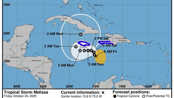
Tropical Storm Melissa is effectively parked in the central Caribbean, dumping devastating amounts of rain on Haiti and Jamaica that has already claimed at least three lives and destroyed one bridge. And more rain is on the way.
The National Hurricane Center doesn’t expect Melissa to pick up the pace for days. Over the weekend, the storm is expected to creep west over some of the hottest waters in the Caribbean — becoming a fountain of rain for the region as it grows stronger and broader.
Jamie Rhome, deputy director of the NHC, said parts of the Dominican Republic have already received 15 or so inches of rain the last few days. In a Friday afternoon broadcast, he called the rainfall forecast “ominous.”
“In the periphery of Haiti and Jamaica, up to 20 inches of rain are possible,” over the next three days, on top of what they’ve already seen, he said. “You’re talking about catastrophic flooding potential.”
By early next week, Melissa is expected to be a formidable Category 4 hurricane that brushes Jamaica and crosses Cuba as it heads northeast back into the Atlantic.
At this point, no long-range models are suggesting Melissa could be a serious threat to Florida.
As of a 12:30 p.m. Eastern time update on Friday, the hurricane center said Melissa had ever so slightly sped up, to only 2 mph, with maximum sustained winds now up to 60 mph. Most of the storm’s rainstorms and strong winds are clustered to the right side.
Haiti’s southwest peninsula and all of Jamaica remain under a tropical storm warning and a hurricane watch. Haiti’s government reported Wednesday that one man died and five others were injured in Melissa-related winds and floods. Two people died and another was injured on Thursday in a landslide in Fontamara, a commune of Port-au-Prince, in the Ouest department.
Melissa’s floodwaters had already begun to claim homes and destroyed at least one bridge in Haiti, officials said.
Over the weekend, Melissa is not expected to move much as it crawls west, drenching the central Caribbean with rain. It’s currently caught in a pocket of wind shear that’s helping to balance out the storm-fueling effects of the warmer-than-average waters its crossing.
But that shear is expected to lighten up in the next few days, giving Melissa the chance to gain the juice needed to hit Category 4 by Sunday evening.
“Once Melissa’s structure improves, environmental conditions still appear favorable for a period of rapid intensification,” forecasters wrote in the 11 a.m. update Friday.
The hurricane center’s forecast track only stretches until Wednesday, when it shows a Category 4 Melissa making landfall on Cuba’s southeast coast. But long-range storm models, also known as spaghetti models, have continued to suggest that Melissa will head northeast after crossing Cuba and bypass Florida.
Exactly when Melissa makes its turn to the northeast is still unclear, and it matters a great deal to Jamaica and Haiti.
An earlier turn could mean a slightly weaker storm, one that is slowed by a landfall on Jamaica before it gets to Cuba and beyond. A later turn gives Melissa more time over some of the hottest waters in the Caribbean, which haven’t seen a storm all season.
“Bahamas, you’re probbaly next,” Rhome said.
_____
(Miami Herald staff writer Jacqueline Charles contributed to this report.)
©2025 Miami Herald. Visit at miamiherald.com. Distributed by Tribune Content Agency, LLC.


Comments