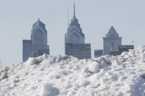
Philly forecast calls for more than a foot of snow to fall Sunday into Monday
Published in News & Features
Philadelphia and its suburbs are forecast to receive 16 to 22 inches of snow and face blizzard conditions beginning Sunday and continuing into Monday, with weather prediction models sharpening their focus as the storm approaches.
“Mother Nature has spoken again and made it clear that winter is not over,” said Mayor Cherelle L. Parker during an emergency press conference, declaring a citywide snow emergency, starting 4 p.m Sunday. “Yet another big winter storm is coming. It’s a major snowstorm with real accumulation anticipated, and it’s heading our way.”
City government and courts will not open Monday, while public schools will switch to virtual learning. SEPTA riders should expect significant service disruptions over the next three days, said officials, who implored drivers to stay off the road Sunday.
Dominick Morales, the city’s emergency management coordinator, described the expected storm as “dangerous,” adding that heavy, wet snow could threaten trees and power lines.
“Dangerous because of the amount of snowfall that is being forecast in about a 24-hour period, but it’s also dangerous because of high winds — and for Philadelphia — near blizzard conditions. When this storm picks up, we have to take it seriously,” he said.
When all is said and done, the total snowfall may be close to 18 inches in the city, and could surpass 20 inches in South Jersey, where high winds are forecast to create blizzard conditions, according to the National Weather Service. Early Sunday morning, the weather service extended a blizzard warning to cover Philadelphia and Bucks and Delaware Counties, as well as eastern Montgomery County and all of South Jersey.
“It does look like it’s going to be quite an impactful storm for the whole (I-)95 corridor and further east,” said Sarah Johnson, warning coordination meteorologist at the weather service’s Mount Holly office, on Saturday.
This will lead to potentially dangerous driving conditions starting Sunday into Monday. And the Shore and Delaware Bay could experience flooding during high tide Sunday evening.
PennDot and the Pennsylvania Turnpike Commission said interstate and I-76 vehicle restrictions are set to begin at 3 p.m. Sunday. Speed limits may be restricted to 45 mph on these roadways, officials said.
While forecasters saw trouble brewing for several days, it was not clear how heavily the storm would affect Philadelphia, Johnson said.
“Pretty much throughout the week, we were aware that there was going to be this storm system off the coast. The question was just going to be how close to the coast it came,” she said.
The storm is expected to begin with a mix of snow and rain Sunday morning, with the potential for only rain falling before dawn. By early to midafternoon, that is forecast to change over entirely to snow, Johnson said.
The blizzard warning is in effect from 10 a.m. Sunday to 6 p.m. Monday.
“We are also going to be seeing some gusty winds with the heaviest snow amounts,” Johnson said. Wind speeds of up to 45 mph late Sunday and early Monday have the potential to cause blowing and drifting snow that may make it difficult to keep roads clear, according to the weather service.
The blizzard warning is in effect from 1 p.m. Sunday to 6 p.m. Monday.
Johnson emphasized that whatever the storm brings, it will be significant for Philadelphia.
“The period that we are most concerned about in terms of both snow rates and wind is Sunday evening through the morning on Monday,” she said.
The storm arrives while the administration is still stinging from criticism over what many perceive as a slow and ineffective response to the January snowstorm, the biggest to hit the city in a decade, which left many neighborhood streets and byways encased in snow and ice for 25 days.
On Saturday, Parker said the city would be ready.
More than 1,000 emergency city personnel, 800 snow removal vehicles, and a reserve of 25,000 tons of salt will be deployed, she said.
“I want to be very clear,” Parker said. “We will do whatever it takes, for however long it takes, to ensure that we have cleared our streets and are keeping Philadelphians safe.”
Snowfall rates could intensify to as much as two inches per hour Sunday afternoon into evening, Parker said.
“It’s going to be a big one, and we’re going to be ready for it,” said Carlton Williams, city emergency management director.
Williams said two high-powered melters, often capable of melting 135 tons of snow per hour, would be strategically placed near residential locations, where snow removal proves difficult, though he did not exactly say where. He said the city is also adding more locations for residents to pile snow.
Williams and other officials requested the public’s help, asking drivers not to block corners, which prevents ploughs from accessing snow-clogged streets. Deputy Police Commissioner John Stanford was clear about parking:
“You cannot save parking spots,” he said. “If we are called to a location for any cones, chairs, or any other items out there, we will remove them.”
All Philadelphia public school activities will be canceled Monday, officials said.
SEPTA is expecting major delays.
“There are going to be significant disruptions to service all throughout the duration,” said SEPTA General Manager Scott Sauer.
In contrast to the very low temperatures for days after the Jan. 25 storm that dumped a foot of snow in areas around Philly, temperatures are expected to rise above freezing on Monday afternoon.
Higher temperatures later in the week may help melt the snow, as opposed to the long-lasting snowpack after the January storm.
Pennsylvania Gov. Josh Shapiro and New Jersey Gov. Mikie Sherrill urged residents in their states to stay off the roads during the storm.
On social media, Shapiro said state agencies are prepared to respond to the weather in Eastern and Southeastern Pennsylvania.
Sherrill on Saturday declared a state of emergency ahead of the storm.
She said at an afternoon news conference that it was the first time since 2022 that the National Weather Service had issued a blizzard warning along the coastline.
The state of emergency will go into effect at noon Sunday.
“I know we just got through a historic winter storm just a few weeks ago — we all did it together by heeding warnings, staying off the roads, and taking public safety seriously,” Sherrill said. “Now we have another serious winter storm on our hands, and my top priority is your safety.”
Officials urged people to stock up on essentials ahead of the storm, keep electronics like cell phones charged, and avoid driving once the snowfall begins.
Sherrill advised New Jerseyans to stay home and suggested watching the U.S. men’s Olympic hockey team play for gold Sunday, doing a puzzle, and eating chili.
_____
(Staff writer Stephen Stirling contributed to this article.)
_____
©2026 The Philadelphia Inquirer. Visit inquirer.com. Distributed by Tribune Content Agency, LLC.


Comments