Northern Michigan riddled with bridge, road collapses from flooding
Published in News & Features

DETROIT — Heavy spring rainfall and lingering melt-off of winter snow and inland lake ice have left much of Michigan's northern Lower Peninsula awash in water this week, wreaking havoc on up north roadways.
Multiple roadways and small bridges were washed away by floodwaters from Grand Traverse County on Lake Michigan to Presque Isle County on Lake Huron in the northeast Lower Peninsula.
Michigan Gov. Gretchen Whitmer has placed the entire state under an energy emergency as some residents in northern Michigan have been urged to evacuate amid flooding that could worsen from Tuesday night storms that swept through much of the Lower Peninsula, producing reports of at least two tornadoes that the National Weather Service is investigating.
Flooding in rivers, creeks, lakes, field drains and ditches is being reported across Alcona, Alpena, Arenac, Charlevoix, Cheboygan, Crawford, Emmet, Iosco, Kalkaska, Leelanau, Manistee, Missaukee, Montmorency, Ogemaw, Oscoda, Otsego, Presque Isle, Roscommon and Wexford counties.
There is also flooding reported in parts of Chippewa and Mackinac counties in the eastern Upper Peninsula, according to the National Weather Service.
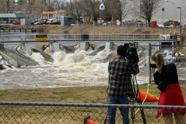
Bridge collapses in Grand Traverse County, state of emergency declared
A state of emergency has been issued in Grand Traverse County due to flooding. The floodwaters have collapsed the Beitner Road bridge south of Traverse City.
The county road commission said the area of Beitner Park is currently closed because the road is washed out after the swollen Boardman River jumped its banks.
"We have a long road of repairs ahead of us," the Grand Traverse County Road Commission said on social media Wednesday morning.
"Once the water recedes, Road Commission staff will conduct an evaluation to determine if it can be safely reopened."
The Grand Traverse County Road Commission said Wednesday afternoon there were closures on Sawyer Road between US-31 and Vance Road; Marsh Road between Clark and Pierce roads; the south end of Bush Road; South Airport Road between Park Drive and Cass Road; Beitner Road between River and Williams roads; and Rahe Road between M-113 and Center Road.
"We appreciate your patience and cooperation as crews work through these conditions. Please respect all closures and signage. Your safety and the safety of others is our top priority," the road commission said.
Roads closed, submerged in Presque Isle, Alpena counties
In Presque Isle County, South Portor Road south of M68, Heythaler west of Klee to Grossman Road, County Road 451 south of Heythaler to Ristow Road, Quade Road at Klee Road and Klee Road between Wenzel and M-68 were closed.
The county also listed Bolton Road from North Grand Lake to 634, County Road 441 to U.S. 23 and Herron Road off McIntosh as "with concerns" because of water on the roadways.
"I am sure in the days ahead we will be adding and removing roads from this list," Presque Isle County's emergency manager Tim Pritchard said in a statement. "Also, I realize there are other roads in the county that have water on them that are not on this list."
Pritchard asked residents to be diligent in protecting their belongings, as basements and homes throughout the county have water issues.
In Alpena County, Grenschaw Road between Princeton and Long Rapids collapsed from the floodwaters. Woodward, Princeton, Sunset, Partridge, Gilchrest, Ford, Wessel, Indian Reserve, Indian, North Pointe, Anderson, Salina, Maple Lane, Scott and Hubert were listed as closed or partially closed roads.
Officials urged caution over Bloom, North Pointe, Huron Beach, El Cajon, Otter Lane and Golf Course roads, according to a Wednesday afternoon news release.
"We continue to encourage individuals to stay away from flooded areas and to not drive through roads that are covered with water," the release states.
Montmorency County braces for more rain in the forecast
In Montmorency County, workers were trying to prevent their dams from breaking — not necessarily for themselves, but for their neighboring counties.
Emergency Management Director Sarah Melching explained that her county has numerous streams and creeks that primarily flow into the Thunder Bay River, which flows into Alpena County. Some of their water also flows north into the Cheboygan area, she said.
"Everybody is impacting everybody at this point," said Melching.
The watershed in Montmorency County is managed by multiple dams, including ones between three successive lakes. The lowest dam in this series has eroded due to moisture, prompting crews to respond with sandbags on Wednesday morning, Melching said.
On Wednesday afternoon, Melching was bracing for more rain in the forecast.
“It’s just monitoring and assessing their dam structures," she said.
Latest on Cheboygan dam flooding
In Cheboygan, state officials spent Monday and Tuesday reinforcing the troubled Cheboygan Lock and Dam Complex, where the water level reached its highest point of the week's flooding on Wednesday morning.
The once privately owned century-old dam in downtown Cheboygan has a long and complicated ownership history that has left part of it in the hands of the Michigan Department of Natural Resources.
State officials have taken a number of measures to prevent the dam from being breached, adding numerous pumps to divert water, giant sandbags, an aqua dam and removing floodgates with a crane.
Some businesses in downtown Cheboygan have barricaded their entrances with sandbags in anticipation of flood waters rushing into the city's central business district.
Flooding trouble along the Little Black River
Late Tuesday afternoon, a levee was breached along the Little Black River watershed north of Cheboygan, flooding a golf course and triggering a flyover of the area by a U.S. Coast Guard helicopter rescue crew.
Cheboygan County's evacuation order for the Little Black River watershed was lifted late Wednesday morning.
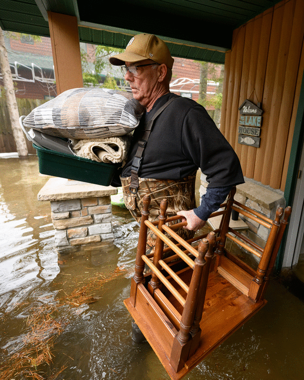
Homes flooded on Mullett Lake in Cheboygan County
On Mullett Lake in Cheboygan County, a tributary of the Cheboygan River, the swollen 16,600-acre lake was starting to surround some homes and cottages with water on Wednesday afternoon.
There was also flooding on nearby Burt Lake, where water was surrounding some homes and overflowing inlets and canals. Near the Sturgeon River, one home had water steadily rising along its side, buoying a stored kayak floating near the house.
_____
(Staff Writer Beth LeBlanc contributed.)
_____
©2026 The Detroit News. Visit detroitnews.com. Distributed by Tribune Content Agency, LLC.


Comments