Eye in the sky: California spending $100M to track methane emissions with satellites
Published in Science & Technology News
California will soon start using satellite technology to track down methane and other greenhouse gas emissions that may otherwise go undetected from sites around the state, such as oil and gas operations, landfills and livestock facilities.
The California Air Resources Board says the first-in-the-nation project will take about $100 million from the state budget to purchase data collected by the satellites about methane plumes.
“The effort provides information that is much closer to real time than the data now available,” Liane Randolph, chair of the board, known as CARB, said in a statement.
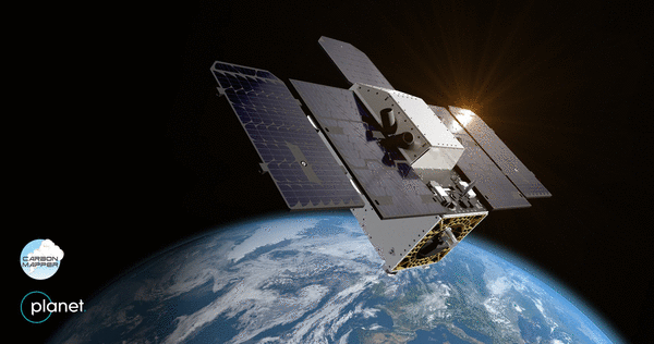
The Tanager-1 satellite was built by Planet Labs PBC, a San Francisco-based, publicly traded company that touts operating the largest fleet of imaging satellites to observe Earth. Planet Labs has launched about 450 satellites and currently operates 200, according to CARB.
Using technology developed at NASA’s Jet Propulsion Laboratory, Tanager-1 has the ability to detect and measure emissions down to the level of individual facilities and equipment.
The lab says the imaging spectrometer aboard the satellite measures hundreds of wavelengths of light that are reflected by the Earth’s surface. Compounds in the atmosphere such as methane and carbon dioxide absorb different wavelengths, leaving “fingerprints” that the spectrometer can identify.
Methane is a major climate pollutant that warms the atmosphere at least 25 times more than CO2, CARB said. Clear and odorless, emissions from the gas account for about one-fourth of global pollution.
CARB already has a regulation in place requiring oil and gas operators in the state to periodically inspect and fix leaks. The new technology will add to the regulatory reporting with monitoring that will be closer to real-time.
The contractor for the California project is Carbon Mapper, a nonprofit based in Pasadena that processes then disseminates the data collected by the satellites.
CARB officials told the Union-Tribune the project’s contract runs through March 2028, but can be extended a year at a time for up to three years.
Tanager-1 is currently in orbit after lifting off from a Space X Falcon 9 rocket last August from Vandenberg Space Force Base in Central California.
CARB said at least four satellites will likely be used during the length of the project, although the contract does not specify the number.
The $100 million the state government is spending on the project comes from money collected by California’s cap-and-trade program that requires power plants, natural gas providers and large industries that emit greenhouse gases to buy permits on the carbon pollution they produce.
Some $95 million will be spent on the satellite data itself, with the remaining $5 million going toward education and applying the data on the local level.
California officials expect to begin receiving the data by this summer. CARB will also manage a database and web portal to coordinate and document mitigation actions.
Before adopting the satellite project, California tracked methane plumes using conventional aircraft.
CARB officials say satellites can survey a much wider area and provide more detailed and continuous information to help determine the size of a leak, its duration and the volume of gas released into the atmosphere.
Conducting a survey from 2016 to 2018 with the Jet Propulsion Lab and the California Energy Commission using technology mounted on conventional aircraft, CARB found that less than 1% of infrastructure in the state accounted for up to 46% of California’s total methane emissions.
“With this new data, we’ll be able to move faster to cut harmful methane pollution — protecting Californians and the clean air we’ve fought so hard for,” Gov. Gavin Newsom said in a statement.
The project comes as the White House and U.S. Environmental Protection Agency administrator Lee Zeldin recently announced the reconsideration of the EPA’s “endangerment finding” — a 2009 determination by the agency that greenhouse gas emissions endanger public health and therefore fall under the Clean Air Act.
“The Trump administration will not sacrifice national prosperity, energy security, and the freedom of our people for an agenda that throttles our industries, our mobility, and our consumer choice while benefiting adversaries overseas,” Zeldin said on March 12.
“Decades of progress to protect public health is on the line with these EPA rollbacks,” Newsom said in his statement. “California isn’t having it. Thanks to our state investment, we’re using satellite technology to detect methane leaks as they happen.”
According to the Jet Propulsion Lab, Tanager-1 can scan about 50,000 square miles of the Earth’s surface each day.
_____
©2025 The San Diego Union-Tribune. Visit sandiegouniontribune.com. Distributed by Tribune Content Agency, LLC.


Comments