Tropical Storm Jerry approaches Caribbean islands, but expected to shift
Published in Weather News
ORLANDO, Fla. — The National Hurricane Center on Thursday said Tropical Storm Jerry was getting closer to the Caribbean’s northern Leeward Islands, but was expected to shift away into the open Atlantic.
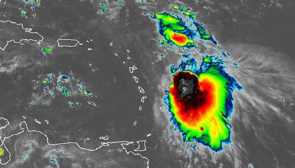
As of the NHC’s 2 p.m. Eastern time advisory, Jerry had maximum sustained winds of 65 mph and was located about 235 miles east-southeast of the Leewards moving west-northwest at 18 mph.
A tropical storm warning was in place for Barbuda, Anguilla, St. Barthelemy, St. Martin and Sint Maarten while a tropical storm watch was in effect for Antigua, St. Kitts, Nevis, Montserrat, Saba, St. Eustatius, Guadeloupe and its adjacent islands.
Tropical Storm Jerry forecast path as of 2 p.m. Thursday, Oct. 9, 2025. (NHC) The system is forecast to shift to the northwest Thursday and the more to the north on on Friday and Saturday.
“On the forecast track, the center of Jerry is expected to pass near or to the northeast of the northern Leeward Islands later today and tonight,” forecasters said. “Gradual strengthening is forecast during the next few days, and Jerry could become a hurricane by late Friday or Saturday.”
Tropical-storm-force winds extend out up to 175 miles from its center.
The intensity forecast only has it as a strong tropical storm with 70 mph sustained winds at its closest approach to the Leewards. It’s then expected to become the season’s fifth hurricane as it moves north, but is not expected to be a threat to land.
The storm is forecast to drop 2-4 inches of rain across the Leeward Islands with wind kicking up late Thursday. Heavy surf should begin hitting the islands earlier and spread to the Greater Antilles on Friday.
The NHC also identified a gale-force, non-tropical area of low pressure in the north Atlantic several hundred miles to the west-northwest of the Azores and said it is producing modest convective activity near its center.
“Some additional subtropical or tropical development of this system is possible over the next couple of days before it moves poleward of the Gulf Steam into a less favorable thermodynamic environment,” the forecasters said.
The NHC gave it a 10% chance to develop within seven days.
Of the 10 named storms so far, four have grown into hurricanes, with three of those reaching major hurricane status. Only Tropical Storm Chantal made a U.S. landfall so far this year.
Hurricane season runs from June 1 to Nov. 30.
------------
©2025 Orlando Sentinel. Visit at orlandosentinel.com. Distributed by Tribune Content Agency, LLC.


Comments