Tropical depression or storm could form today in Atlantic, hurricane center says
Published in Weather News
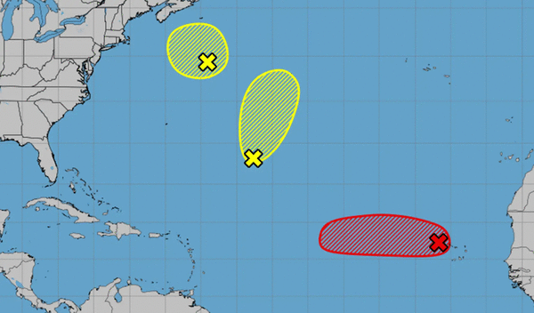
ORLANDO, Fla. — The National Hurricane Center on Monday forecast a system in the Atlantic could develop into a tropical depression or storm as soon as this morning while tracking two other Atlantic systems.
As of the NHC’s 8 a.m. tropical outlook, the system dubbed Invest 97 has persistent shower and thunderstorm among signs of organization around a well-defined area of low pressure just west of the Cape Verde Islands.
“If these structural trends continue, the system is likely to become a tropical depression or storm, possibly as soon as later this morning,” forecasters said.
If it does it could become Tropical Depression Five or if powerful enough, Tropical Storm Erin.
Long-term models have the system continuing west and potentially developing into the season’s first hurricane later in the week.
It’s too early to tell if the system will have any impact on Florida or elsewhere in the U.S.
Heavy rainfall and gusty winds are expected to drop across portions of the Cape Verde Islands today.
“Regardless of development over the next couple of days, the system is expected to continue moving westward to west-northwestward at 15 to 20 mph across the eastern and central tropical Atlantic,” forecasters said,
The NHC gave it a 90% chance to develop in the next two to seven days.
The NHC was also tracking two other Atlantic systems, but both with just a 10% chance to develop in the next to days.
One in the central Atlantic was a weak trough of low pressure with limited shower and thunderstorm activity.
“Significant development of this system is becoming unlikely over the next few days as the system drifts generally northward, remaining over the central Atlantic,” forecasters said.
The second, newly tracked on Monday morning, was a a nontropical area of low pressure a few hundred miles to the south-southeast of Nova Scotia, Canada.
“While current shower and thunderstorm activity with the system is limited, this system is drifting over the warm waters of the Gulf Stream where some tropical or subtropical development could occur over the next day or two,” forecasters said. “By the middle of this week, the system is expectedto move northward over cooler waters, ending its changes for further tropical development.”
After Erin, the next names on the 2025 Atlantic hurricane season would be Fernand and Gabrielle.
The National Oceanic and Atmospheric Administration this week updated its season forecast now calling for 13-18 named storms for the year, of which five to nine would grow into hurricanes. Two to five of those would develop into major hurricanes of Category 3 strength or higher.
The height of hurricane season runs from mid-August into October.
The entire six-month season runs June 1 to Nov. 30.
-----------
©2025 Orlando Sentinel. Visit at orlandosentinel.com. Distributed by Tribune Content Agency, LLC.


Comments