Tropical Storm Erin forms, forecast to become major hurricane, NHC says
Published in Weather News
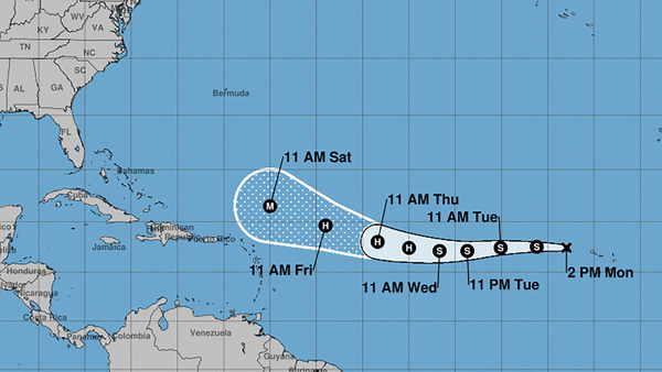
ORLANDO, Fla. — Tropical Storm Erin formed in the eastern tropical Atlantic on Monday morning and is forecast to grow into a major hurricane by the weekend, according to the National Hurricane Center.
As of the NHC’s 2 p.m. Eastern time update, the newly formed storm was located about 280 miles west-northwest of the Cape Verde Islands and 2,305 miles east of the northern Leeward Islands of the Caribbean moving west at 20 mph with maximum sustained winds of 45 mph. Tropical-storm-force winds extend out 35 miles.
“This motion is expected to continue for the next several days,” forecasters said. “Gradual strengthening is forecast over the next several days.”
The long-range forecast from the NHC has it intensifying into what would be the season’s first hurricane with 80 mph sustained winds, making it a Category 1 hurricane, by Wednesday night.
The forecast also predicts it will grow into a major Category 3 hurricane with 115 mph sustained winds by Saturday night, with the cone of uncertainty encompassing a wide swath in the Atlantic just northeast of the Leeward Islands. Winds could potentially be felt in the islands beginning Friday night.
Heavy rainfall and gusty winds are expected to drop across portions of the Cape Verde Islands Monday.
The National Weather Service in Melbourne said it was too early to determine if there would be any Florida impacts.
“We are entering peak hurricane season. Use this time to ensure you are prepared ahead of any threats,” forecasters said.
Computer modeling forecast tracks from Monday mostly show the storm veering to the north before it would threaten the U.S. but patterns can change, and some have that shift to the north closer to the Florida coast.
The NHC was also tracking two other Atlantic systems and a system in the Gulf.
As of the NHC’s 2 p.m. tropical outlook, the two Atlantic systems had only a 10% chance of development, while the Gulf system had 0% chance but forecasters warned of tropical rainfall over the Florida panhandle.
That weak surface trough in the northeastern Gulf near the Florida coast was associated with a broad area of disorganized showers and thunderstorms.
“While development of this system is not anticipated before it moves inland, locally heavy rainfall could produce flash-flooding along portions of the Florida Panhandle over the next day or so,” forecasters said,
One of the two other systems was a weak surface trough located in the central Atlantic that was interacting with an upper-level trough with scattered disorganized shower and thunderstorm activity.
“Significant development of this system appears unlikely over the next few days as the system drifts generally northward, remaining over the central Atlantic,” forecasters said.
The other was a nontropical area of low pressure a few hundred miles south-southeast of Nova Scotia, Canada.
“While current shower and thunderstorm activity with the system remains limited, this system is drifting over the warm waters of the Gulf Stream, and some tropical or subtropical development could occur over the next day or two,” forecasters said. “By the middle of this week, the system is expected to move northward over cooler waters, ending its chances for further tropical development.”
After Erin, the next names on the 2025 Atlantic hurricane season would be Fernand and Gabrielle.
The National Oceanic and Atmospheric Administration last week updated its season forecast, now calling for 13-18 named storms for the year, of which five to nine would grow into hurricanes. Two to five of those would develop into major hurricanes of Category 3 strength or higher.
The height of hurricane season runs from mid-August into October while the entire six-month season runs June 1 to Nov. 30.
_____
©2025 Orlando Sentinel. Visit orlandosentinel.com. Distributed by Tribune Content Agency, LLC.


Comments